FEMA FIRM Revisions
From time to time, the Federal Emergency Management Administration (FEMA) updates Flood Insurance Rate Maps (FIRMs). These are the maps that show the risk any given structure or property has of being inundated by a 100-year flood. Carroll County received FIRMs in 1981, which were then updated in 2015.
Over the last few years, Frederick and Howard Counties were issued new FIRMs by FEMA, and Carroll County’s FIRMs are being updated to match those of its neighboring jurisdictions. The study area includes portions of unincorporated Carroll County, as well as portions of the Towns of Mt. Airy, New Windsor, Sykesville, and Union Bridge. In 2024, FEMA provided new preliminary FIRMs for parts of Carroll County. All of the maps can be viewed here. Click here for an infographic about Carroll County and the Towns being impacted by these map changes. For more information about the map change process, please click here.
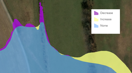
For the entire county, the proposed map changes show 10 structures being newly mapped in to the FEMA floodplain and five structures being newly mapped out of the floodplain. The image below shows areas being newly mapped in to the FEMA Floodplain as yellow and areas being mapped out as purple. To see all of the areas where the floodplain will expand or contract based on the new engineering analysis, please click here.
Any property owner can purchase flood insurance. However, if a structure is located in the floodplain, and the property is paid for using a federally-back mortgage, flood insurance must be purchased to comply with Federal law. For specific questions about flood insurance, policies, rates, and coverage, please click here.
FEMA met with staff and elected officials from Mt. Airy, New Windsor, Sykesville, and Union Bridge as well as Carroll County, to discuss the process of revising FEMA floodplain maps. This began the appeal period for the map changes. The new maps are expected to become official in the fall of 2026. Residents, property owners, and the local development community are encouraged to review the maps and reach out to Patrick Varga, CFM with any questions.